Why it is worth riding
A ticketed seasonal rail-trail adventure from East Portal to Pearson, pairing the 1.66-mile Taft Tunnel with high trestles and a shuttle-assisted return.
A ticketed seasonal rail-trail adventure from East Portal to Pearson, pairing the 1.66-mile Taft Tunnel with high trestles and a shuttle-assisted return.
CORE INFORMATION
WHY IT’S FUN
The Route of the Hiawatha turns an ambitious piece of railroad engineering into a ride that feels like a sequence of reveals. The standard 2026 itinerary begins at East Portal, passes through the 1.661-mile St. Paul Pass—or Taft—Tunnel, descends 14.4 miles to Pearson, and uses the paid shuttle to return to Roland. Riders parked at East Portal then pedal through the long tunnel a second time, bringing typical riding distance to about 16.4 miles (26.4 km).
The opening tunnel is not a warm-up. It is completely unlit, cold at roughly 47°F year-round, wet in places and long enough for the entrance behind you to disappear before the exit becomes convincing. A tightly focused 300–400 lumen handlebar light is required. The best experience comes from slowing down, removing sunglasses before entry and letting the sound of water, tires and voices define the space without stopping in the travel lane.
Emerging at the west portal feels theatrical: daylight, forest and the old railroad grade suddenly replace the tunnel’s black interior. Roland provides a useful regrouping point and the option to begin for riders who want to bypass Taft Tunnel. From there, the route settles into a gentle 1.5–2% descent on firm gravel, following broad curves designed for trains rather than bicycles.
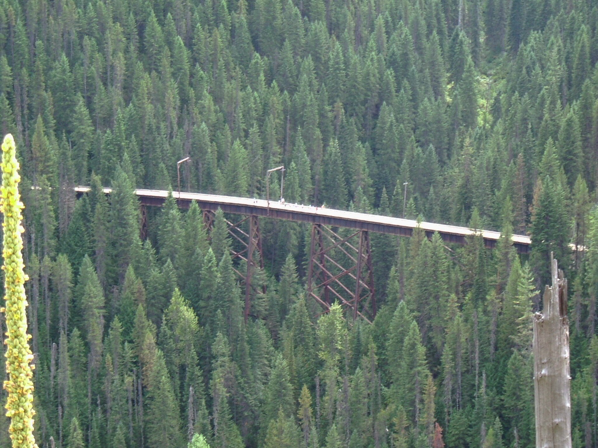
The steel trestles are the visual signature. They lift riders above deep, forested drainages and expose the scale of the Bitterroot Mountains without requiring a hard climb. In 2026, the trail remains open, but a Forest Service notice dated May 27 closes all trestle and bridge walkways while remediation is underway. Stay on the designated riding surface, do not enter barricaded areas and expect staff or maintenance equipment near work zones.
Between the major structures, the pleasure is quieter: filtered mountain light, interpretive signs, old railway cuts and repeated glimpses of the line curling across the opposite slope. The surface changes from fine gravel to coarser dirt and small cobble, so wide tires and calm braking make the ride more enjoyable. Narrow road tires are seen here but are specifically not recommended by the operator.
The railroad story gives the scenery weight. Thousands of workers from numerous immigrant communities built the Milwaukee Road’s Pacific extension between 1906 and 1911. Its tunnels, electrification infrastructure and high bridges represented extraordinary industrial ambition. After the railroad’s bankruptcy, the Forest Service, volunteers and partner organizations converted the grade into a fee-supported public trail.
This route works especially well for friends, couples and families whose younger riders already brake, steer and hold a line confidently. The descent is gentle, but darkness, loose gravel, two-way bicycle traffic and exposed trestles demand attention. Anyone anxious about the long tunnel can start at Roland, while riders wanting a harder day can climb from Pearson and return downhill without the shuttle.
Logistics shape the experience. Lookout Pass at I-90 Exit 0 is the ticket, rental and information center, but it is not connected to the riding trail by shuttle. Most riders drive to East Portal from Exit 5 at Taft. At Pearson, buses return riders and bicycles to Roland on a first-come basis; waits of 30–45 minutes or more are possible on busy afternoons. Early starts are more relaxed.
For 2026, the verified season runs May 22 through September 20, with facilities opening at 8:00 a.m. and the trail at 8:30 a.m. Pacific Time. Weather can alter operations. Tour de Fun links only the official operator map and Forest Service information; it does not present an unverified GPX or third-party route link. What makes this ride special is not simply that a railroad became a bike path, but that every tunnel and trestle changes the rider’s sense of scale, sound and exposure.
Source-backed, not locally verified: This is an editorial guide, not live navigation. Check closures, detours, weather, traffic and access rules with the source immediately before riding.
A ticketed seasonal rail-trail adventure from East Portal to Pearson, pairing the 1.66-mile Taft Tunnel with high trestles and a shuttle-assisted return.
The Loop Creek trestle corridor delivers the grandest elevated views, while the first emergence from Taft Tunnel creates the ride’s strongest change of atmosphere.
Do not linger inside tunnels or on active riding surfaces. Use East Portal, Roland, Adair and Pearson for practical pauses, and obey the 2026 closure of trestle and bridge walkways.
Best for families whose children already control a bicycle confidently, groups and couples seeking a memorable half-day adventure. Riders uncomfortable with darkness, loose gravel, heights or shuttle logistics should consider a shorter Roland start or another route.
Thousands of workers from many immigrant communities built the Milwaukee Road’s Pacific extension between 1906 and 1911. The Forest Service and volunteers later transformed the abandoned grade into today’s fee-supported rail-trail.
ROUTE MAP
Tour de Fun does not rebuild navigation. Start with U.S. Forest Service and Route of the Hiawatha official operator for the published route, map files, closures and local rules. The planning-platform links below open mature tools; they are not claimed to be the same verified track.
FUN STOPS
Location: Lookout Pass Ski & Recreation Area beside I-90 Exit 0 on the Idaho–Montana state line, about seven road miles from East Portal. Role in the ride: collect tickets, rentals, helmets, lights, maps and food before driving to the trail. What to see or do: confirm the day’s alerts, shuttle choice and bike-light setup. Recommended stop: 30–60 minutes before the booked start. Distance from route: off route; this is the service center, not a shuttle-served trailhead. Bike parking: rental and visitor facilities are available, but do not assume secure overnight storage. Hours: facilities open at 8:00 a.m. in the verified 2026 season; check current operator hours. Practical note: the trail shuttle does not transport guests from Lookout Pass. Photo: actual Hiawatha Trail context by Robert Ashworth, CC BY 2.0, Wikimedia Commons.
Location: East Portal trailhead, reached from I-90 Exit 5 at Taft, Montana, via Route 506 and the signed access road. Role in the ride: park, display the required ticket, test lights and enter Taft Tunnel. What to see or do: use the restroom, check layers and listen to staff instructions. Recommended stop: 15–20 minutes. Distance from route: on route. Bike parking: standard trailhead staging; keep bikes attended and lock unattended equipment. Hours: trail opens at 8:30 a.m. Pacific Time during the 2026 operating season. Practical note: start early to reduce afternoon shuttle queues. Photo: exact Taft Tunnel on the Hiawatha Trail by Robert Ashworth, CC BY 2.0, Wikimedia Commons.
Location: west portal of the St. Paul Pass, also called Taft, Tunnel at the Idaho side of the state line. Role in the ride: safely clear the tunnel, restore layers and regroup before descending. What to see or do: notice the abrupt transition from cold darkness to mountain forest and old railway engineering. Recommended stop: 5–10 minutes only where fully off the riding line. Distance from route: on route. Bike parking: no secure racks verified; keep the bicycle with you. Hours: seasonal trail hours apply. Practical note: do not stop inside the tunnel; the surface near gutters can be wet and slippery. Photo: actual Hiawatha Trail by Robert Ashworth, CC BY 2.0, Wikimedia Commons.
Location: Roland trailhead roughly a quarter mile below the Taft Tunnel west portal. Role in the ride: practical regroup, alternative start for riders bypassing the long tunnel, and the shuttle’s upper drop-off. What to see or do: review the map and prepare for the gravel descent. Recommended stop: 10 minutes. Distance from route: on route. Bike parking: trailhead facilities; secure overnight storage is not verified. Hours: seasonal operating hours apply. Practical note: buses travel between Pearson and Roland only; riders parked at East Portal must pedal through Taft Tunnel again after the shuttle. Photo: actual Hiawatha Trail by Robert Ashworth, CC BY 2.0, Wikimedia Commons.
Location: Adair on the official Hiawatha map, along the downhill route between Roland and Pearson. Role in the ride: one of the corridor’s designated practical rest points. What to see or do: use facilities, check children’s comfort, lights and brakes, and enjoy the railway setting without blocking the trail. Recommended stop: 10–15 minutes. Distance from route: on route. Bike parking: no verified secure racks; keep bikes together and attended. Hours: seasonal facilities may vary, so confirm current availability. Practical note: carry your own water and snacks rather than treating Adair as commercial resupply. Photo: actual Hiawatha Trail by Robert Ashworth, CC BY 2.0, Wikimedia Commons.
Location: the official trail’s high-trestle corridor above the forested Loop Creek drainage. Role in the ride: the most dramatic elevated scenery and railway-engineering sequence. What to see or do: look across the slope for the track’s curves, tunnels and trestles while maintaining a predictable line. Recommended stop: only at designated pull-offs, never on the active riding surface. Distance from route: on route. Bike parking: none verified; keep the bike with you. Hours: seasonal trail hours and work-zone controls apply. Practical note: as of the May 27, 2026 notice, all trestle and bridge walkways are closed; obey barriers and remain on designated riding surfaces. Photo: actual Hiawatha Trail by Robert Ashworth, CC BY 2.0, Wikimedia Commons.
Location: Pearson, Idaho, the lower-elevation end of the standard 14.4-mile descent. Role in the ride: finish, use restrooms and join the first-come shuttle queue to Roland. What to see or do: organize bikes for loading, keep tickets accessible and allow time for queues. Recommended stop: normally 30–60 minutes depending on demand. Distance from route: on route. Bike parking: shuttle staging rather than secure storage; remain with the bicycle. Hours: 2026 last shuttles vary by season and day, commonly 4:15 p.m., with later peak-weekend service. Practical note: the transfer takes about 35 minutes and does not return riders to East Portal; plan the second Taft Tunnel passage. Photo: actual Hiawatha return bus trip by Robert Ashworth, CC BY 2.0, Wikimedia Commons.
BEFORE YOU RIDE
A focused 300–400 lumen handlebar light is required and helmets must be worn. Remove sunglasses before tunnel entrances, aim the beam 10–15 feet ahead, allow eyes to adjust and walk if uncertain. The Taft Tunnel is unlit, about 47°F year-round, wet and slippery near its gutters. Keep right, pass left with an audible warning, never stop in a tunnel, control speed on gravel and obey staff around maintenance equipment. The May 27, 2026 Forest Service notice keeps the trail open but closes all trestle and bridge walkways; do not enter barricaded areas.
The verified 2026 operating season is May 22 through September 20, subject to weather adjustment. Mountain conditions can bring rain, cold air and rapid temperature changes even when valleys are warm. Pack a jacket and rain layer; tunnel interiors remain cold and damp. Wildfire smoke can affect late-summer riding, so check forecasts, webcams and official alerts before travel.
Bring water and snacks from Lookout Pass or East Portal. There is no dependable commercial resupply along the riding corridor. Restrooms are available at trailheads, Roland, Adair and Pearson, but seasonal facilities should be confirmed before relying on them.
No public transit serves the trail itinerary. The paid trail shuttle operates only between Pearson and Roland—not from Lookout Pass or directly back to East Portal. After the bus ride, riders parked at East Portal pedal through the 1.661-mile Taft Tunnel again. Reserve tickets and suitable specialty-bike handling in advance.
Most riders park at East Portal after driving from I-90 Exit 5 at Taft, Montana, then about 2.5 miles on Route 506. Lookout Pass at I-90 Exit 0 is the ticket, rental and information center but the trail shuttle does not serve it. Forest roads to Roland and Pearson are narrow, slow and not recommended as the standard approach.
Every user must buy and display a trail ticket. Helmets and lights are mandatory; children under 14 require adult supervision. Pets are prohibited except trained service animals. Keep right, yield appropriately, pack out all waste, leave artifacts in place and follow all posted closures. In 2026, trestle and bridge walkways are closed even though the riding route remains open.
COMMUNITY PHOTOS
Community photos will appear only after real riders submit images and permission to publish their account credit.
Submit a ride ↗RELATED RIDES
 FUN 8.9↗
Truckee, California · United States
 FUN 9.1↗
Portland, Oregon · United States
 FUN 8.8↗
Redmond–Woodinville–Bothell, Washington · United States
This guide uses route information from U.S. Forest Service and Route of the Hiawatha official operator. Some catalogue images are representative of the route region. Tour de Fun is a free editorial community, not a navigation or commerce service.